As cities across Europe work to modernise public transport systems and improve safety and inclusivity, Vic has been selected as part of the CulturalRoad Catalonia demonstration site to validate how data-driven mobility insights can support these ambitions. Several approaches are employed to gather the data required to analyse the city’s needs and develop a roadmap for integrating CCAM solutions into mobility ecosystems. In addition to the collection of data from public and partner sources, as well as focus groups and workshops, the CulturalRoad project takes advantage of data directly captured within the city thanks to a recording vehicle equipped by our partner FICOSA with advanced perception sensors and a suite of algorithms capable of capturing real-world mobility conditions.
Objective of the pilot in Vic
The objective of the pilot is first to enhance the analysis conducted following the implementation of the CulturalRoad Five-Pointed Star Rating System in the five demonstration sites of the project, which will primarily use aggregated data at spatial and population levels, supplemented by a more granular analysis at the individual level, covering both infrastructure (exact event locations) and road users (vehicle interactions with individuals). The pilot also demonstrates the framework’s adaptability and transferability to specific environments where particular analyses will be conducted focusing on some of the possible outputs of the Five-Pointed Star Rating System. More specifically, the pilot aims to evaluate the impact of changes introduced in Vic’s bus network on traffic efficiency, safety and accessibility. It also explores how vulnerable road users interact with traffic in particular boundary conditions, and how automated systems should be designed to better serve them. This pilot therefore stands at the intersection of optimisation, inclusivity and safety, aligning with policy goals across Catalonia for smarter, fairer and safer urban mobility.
In addition, the pilot aims to contribute to the global development of sustainable mobility, in line with the National Mobility Guidelines. These policies serve as a framework for promoting sustainable mobility in Catalonia, addressing new social needs, evolving citizen habits, territorial uses, and infrastructure requirements to drive the necessary regulatory changes.
Recording car and algorithms
For the pilot, the FICOSA team has equipped the company’s demonstration vehicle with a state-of-the-art camera-based Surround View System, complemented by LiDAR and differential GPS. These sensors are integrated using advanced calibration and data synchronisation techniques, enabling the accurate capture of several urban areas in Vic. In parallel, FICOSA’s data engineering and tooling teams have developed the necessary data infrastructure to implement multiple processing pipelines capable of handling the large volumes of multimodal sensor data generated by the vehicle. The result is a comprehensive and geo-referenced dataset reflecting real mobility conditions, including pedestrian presence and vehicle dynamics.
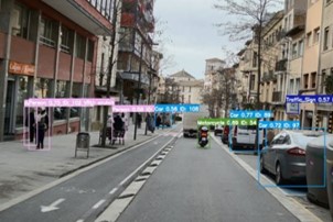
Several algorithms are then used to extract meaningful information from this raw data. Road users, including vulnerable users and users with physical disabilities, are identified using deep learning–based object detection and tracking models adapted specifically to the vehicle’s sensor configuration. Beyond simple detection, the system infers behavioural patterns such as awareness of the vehicle, intention to cross, and adjustments in walking speed or trajectory. At the same time, the car logs contextual metadata including GPS coordinates, timestamps, and vehicle actions such as acceleration or braking. This structured combination of perception data and vehicle dynamics makes it possible to aggregate observations over time and identify recurring activity patterns or potential risk hotspots.
Early recording sessions in Vic have already produced first results. This phase focused on tuning the algorithms and refining the routes and sessions to ensure the most relevant and representative data was recorded. The initial processing of the data shows that road users can be reliably detected with consistent class labelling. Combining these detections with contextual information will allow the creation of a representative picture of the mobility conditions in Vic.
Value of the data for the five-pillar system
Compared with the conventional data typically available to public authorities, the data collected by the recording vehicle provides detailed, synchronised, behaviour-level insights. It not only captures where and when road users are present, but also enables dynamic monitoring across different areas of the city thanks to the vehicle’s mobility and multi-sensor configuration. This makes it possible to generate fine-grained maps of occupancy and real interactions, supporting network optimisation and safety assessment.
Particular emphasis is placed on detecting vulnerable users, including people with physical disabilities, in order to evaluate and strengthen the inclusiveness of CCAM solutions deployed in the city. More broadly, this approach shows how CCAM-equipped vehicles can act as mobile sensing platforms that continuously enrich the evidence base for smarter urban mobility planning.
Next steps
In the coming months, the project will expand data collection to cover additional time periods and repeat routes several times, while refining detection algorithms. The next phases will include extracting and pre-processing the full data, as well as sharing them, together with the corresponding videos, with the academic partners so that they can apply the relevant parts of the Five-Pointed Star Rating System frameworks and obtain the relevant KPIs for the Vic pilot. This exercise also allows the delivery of concrete recommendations to the city of Vic for infrastructure and network improvements. The application of the framework to these granular data could also inspire methodological improvements for future similar uses of the CulturalRoad Five-Pointed Star Rating System.